Unknown Luton Road
Background #
In “Britain in old photographs: Luton a second selection” the author Stuart Smith reproduces a specific road in Luton on page 126, a location he has not been able to identify. Given this, I decided to attempt to geolocate the image. It was a challenging task, as there was little initial information to go on, but it was certainly worth the attempt.
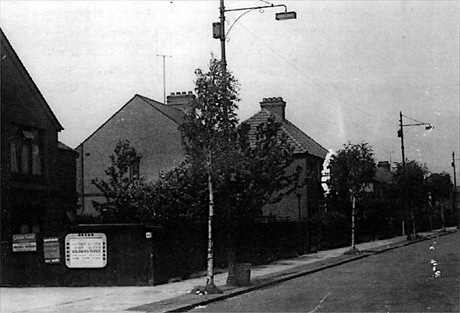
Figure 1: The unknown road in Luton. Enlarged version.
Initial Evidence #
Upon analysing the photograph, I found more clues than I had initially expected, even if the context remained limited:
- Commercial Frontage: A visible shop front, featuring signage displayed on a wooden fence.
- Infrastructure: An “H” fire hydrant sign fixed to the fence, and what appears to be a junction box attached to a lamp post.
- Branding: An old Brookbond Tea enamelled metal sign on the fencing, strongly suggesting the premises housed a general shop.
- Modern Detail: VHF TV antennas installed on the houses.
- Architecture: Three small, pip-like brick features located just below the rim of a chimney stack.
- Property Details: Details of the roof shape, window placement, and property extensions.
- Flora & Season: Several Silver Birch trees planted along the roadside. They appear to have only recently come into leaf, suggesting the photograph was likely taken in late April or May.
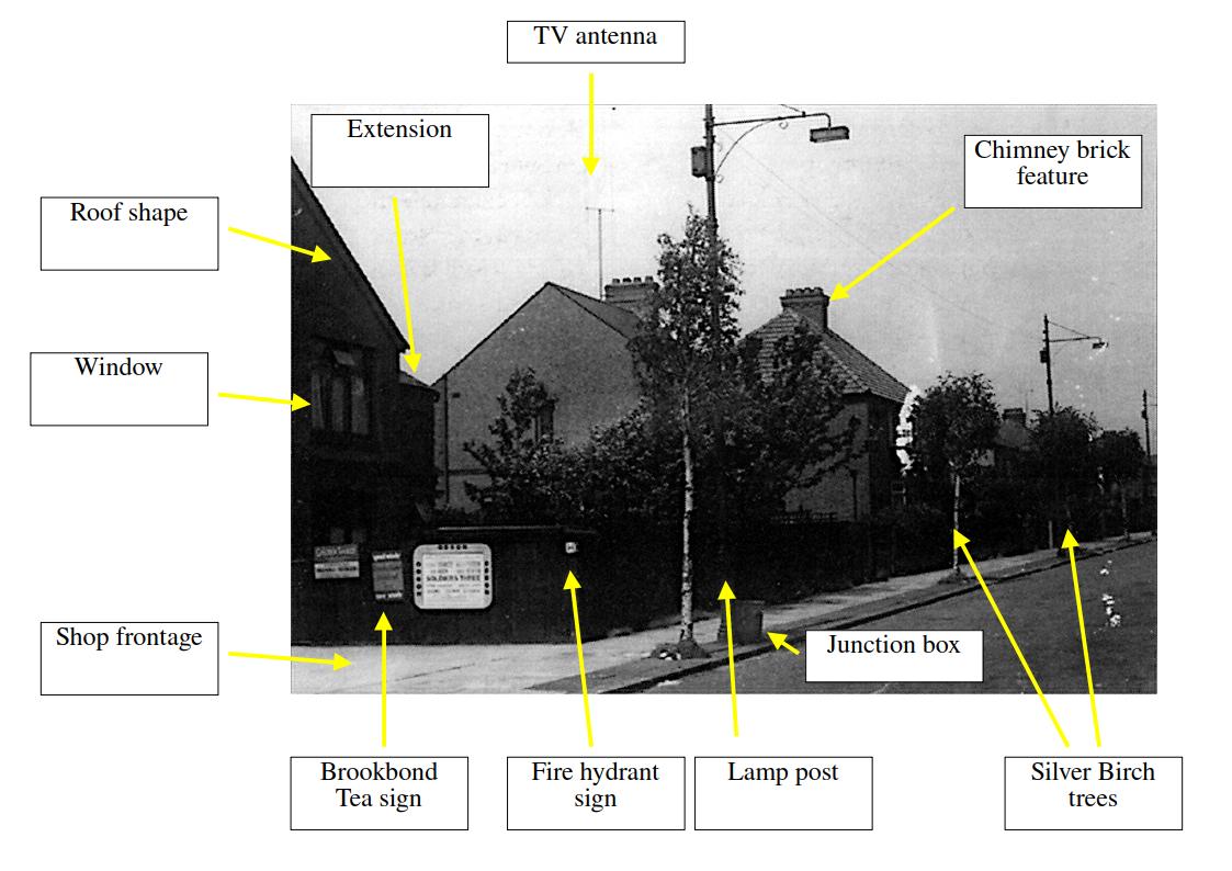
Figure 2: The unknown road in Luton initial evidence. Enlarged version.
Lacking broader contextual leads, my best hypothesis was that the shop front was located on a road corner. Corner shops were ubiquitous in that era, making it a sensible starting point for the investigation.
The Corner Shop Dataset #
To narrow down the search, I used OpenStreetMap to download all modern shop locations and corresponding road paths within Luton. My objective was to create a database of road intersections and then perform a geospatial query. I searched for shops located within 25 metres of a road junction.
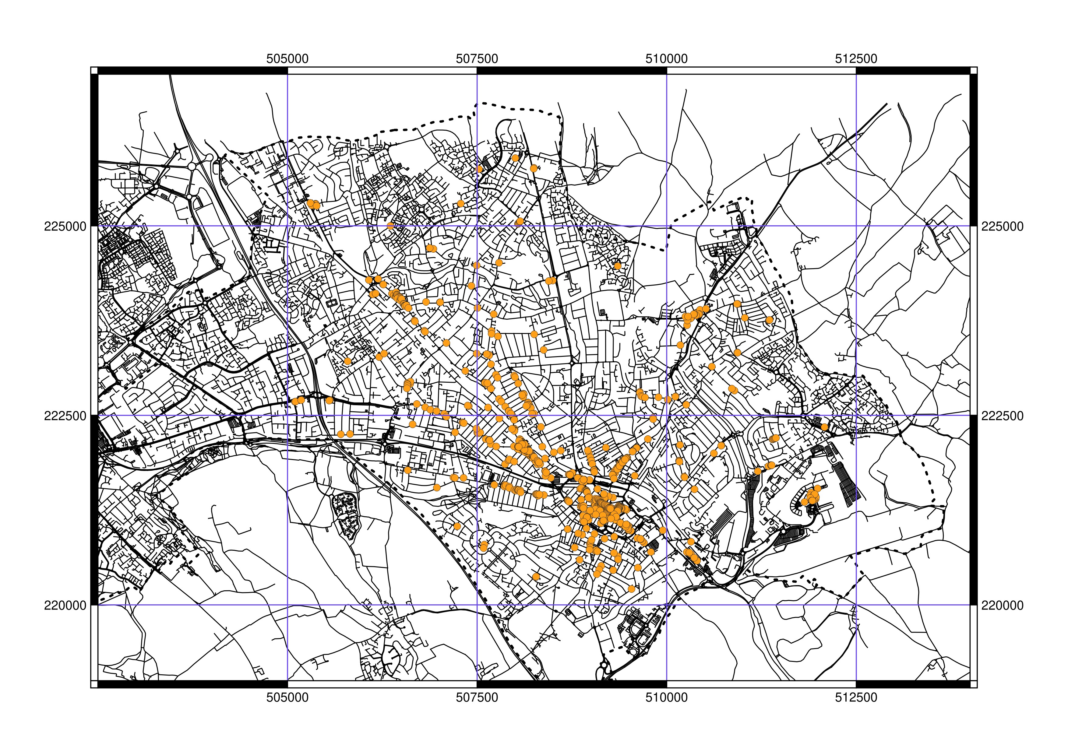
Figure 3: The map of shops within 25 metres of a road junction. Enlarged version.
This initial filter dramatically reduced the dataset. Starting with 925 listed shops, the query successfully narrowed the possibilities down to 693 shops located near an intersection. Although this was still a considerable amount of work, I expected the road in the photograph to be located in a suburb rather than the town centre, where shop density is highest.
The Search Commences #
The next phase involved systematically working through the GIS map, examining the corner shops grid square by grid square. I matched each marked location against the satellite imagery backdrop. When a location appeared promising, I conducted a closer inspection using Google Street View. About halfway through this painstaking process, I found a match.
Results #
The location corresponds to a corner shop at the western end of Woodland Avenue, where it joins Leagrave Road.
When viewing the scene from a position approximately matching where the historical photograph was taken, the following points were consistent:
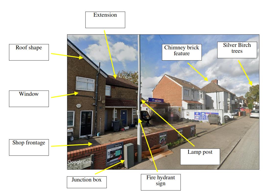
Figure 4: Woodland Avenue, showing correlating evidence to the original historical photograph. Enlarged version.
- Building Consistency: The roof shape, window locations, extensions, and overall shop frontage are consistent with the historical image. (Note: The original fencing has since been removed.)
- Street Furniture: The lamp post is positioned in the same spot, although the junction box has been replaced and relocated.
- Hydrant: The fire hydrant sign has been repositioned from the fence to the lamp post. There is clearly a water access cover nearby, though I was unable to locate it in the modern imagery.
- Properties: The first house along the road is set back as in the original, though it has been significantly modernised. The gable-end window present in the original is missing from the modern scene.
- Chimney: The chimney brick features on the second house are still present in the modern imagery.
- Trees: The first two Silver Birch trees visible in the original photo are missing from the modern view, although a row of similar trees continues further down the road.
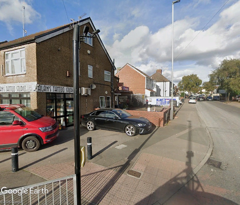
Figure 5: Woodland Avenue corner shop. Enlarged version.
Estimating the Date of the Photograph #
The 405-line VHF TV antenna visible in the historical photograph provides a significant clue regarding the era. VHF TV transmissions on this frequency began in 1936 but were decommissioned between 1982 and 1985. Therefore, I estimate the original photograph was taken sometime in the 1960s or perhaps earlier.
Coupled with the observation about the Silver Birch trees, the photograph was likely taken in late April or May.
Furthermore, observing the shadow cast by the lamp post running along the road’s axis in the historical image, I used the map’s orientation to calculate the sun’s position. For May 1st, the shadow would run along the road’s axis around 15:00 hours. Based on this, and acknowledging that this is only a rough date estimate, the original photograph was likely taken roughly in the mid-afternoon.
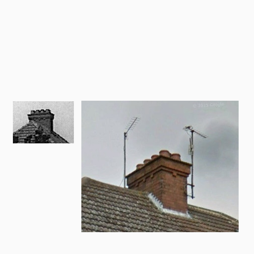
Figure 6: Chimney feature comparison of historical and modern images. Enlarged version.
Conclusions #
Considering all the evidence, from the consistent architectural features to the geospatial match, I am highly confident that the original photograph was taken at the corner of Woodland Avenue in Luton. Another mystery has been solved.
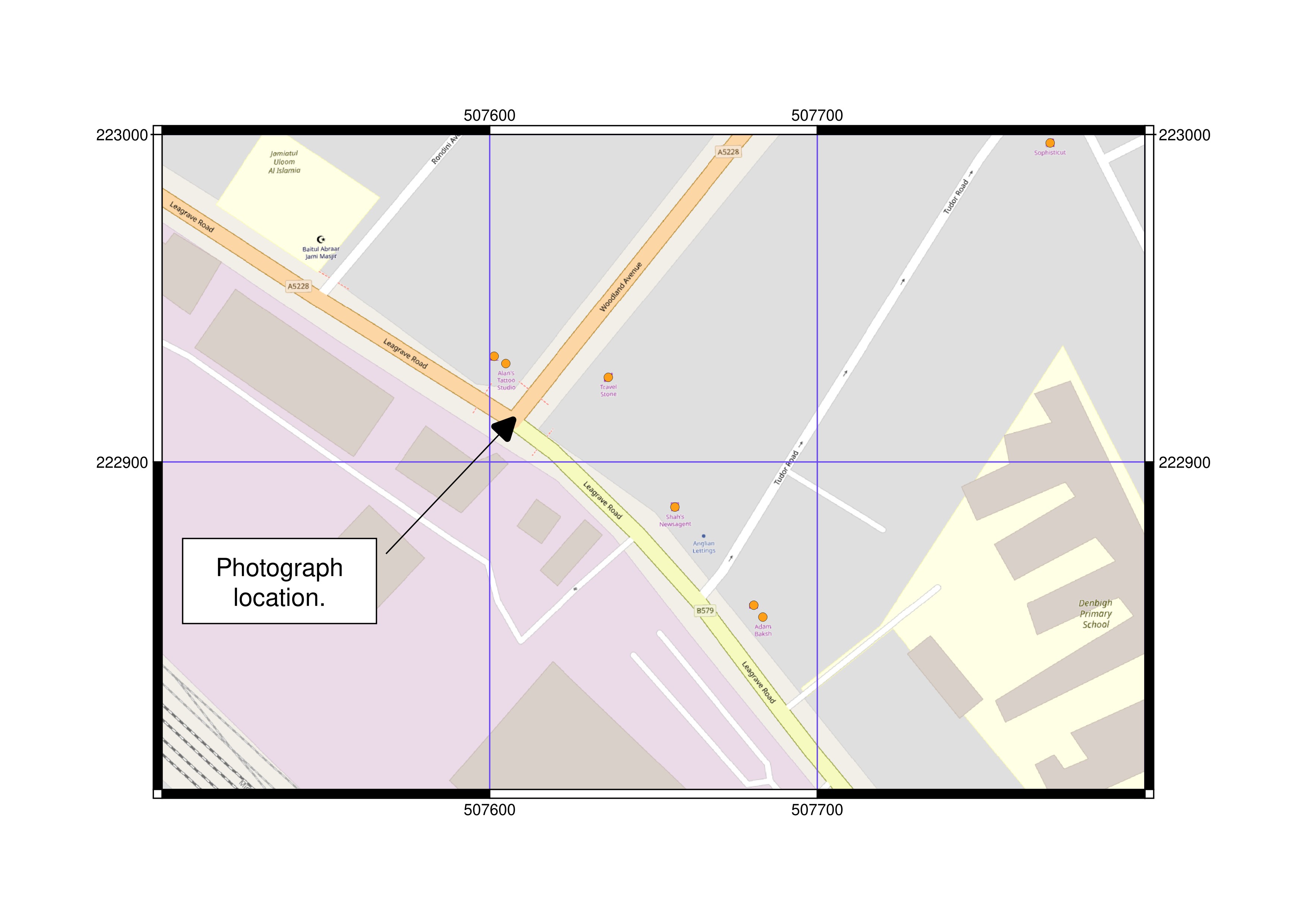
Figure 7: Woodland Avenue map, showing the approximate position of where original photograph was taken. Enlarged version.
Had my initial hypothesis about the shop being on a corner been incorrect, significantly more searching would have been required. Alternatively, the shop may have been redeveloped into a private dwelling and consequently excluded from the geographical database. This kind of investigative work demonstrates that a healthy dose of intuition and luck is often required when dealing with such limited initial information.
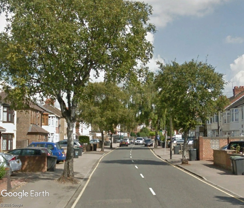
Figure 8: Mature Silver Birch trees a little further down Woodland Avenue. Enlarged version.
Page updated: Tuesday, November 17, 2026.