Unknown Luton house
Background #
In “Britain in Old photographs: Luton” Stuart Smith reproduces a photograph of an old house in Luton on page 126 of his book. Smith notes that he was unable to determine the location of this specific house. He goes on to suggest that the building was demolished around 1970 and might have been known as Bedford House.
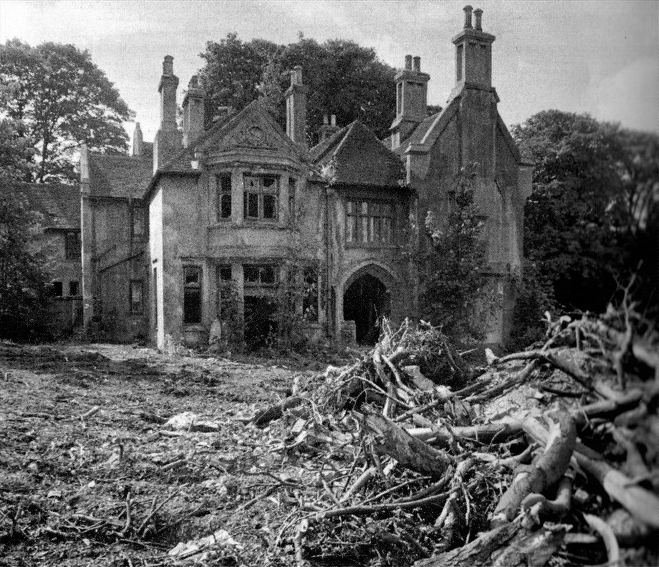
Figure 1: The unknown Luton house. Enlarged version.
During the early 2000s, after seeing the photograph, I performed a cursory scan of an old 1922 Luton map that I owned. I identified Highfield House as a building that was clearly not marked on the modern Ordnance Survey map. Furthermore, from the historical map, Highfield House had approximately the same geometry as the house shown in the historical photograph. However, at that time, I decided to set the project aside.
Over Christmas 2023, I decided to take a closer look at identifying the house again, this time adopting a more structured approach to the problem.
Initial Clues #
Taking a fresh look at the issue, I annotated the photograph (Figure 2) with possible clues that could aid in geolocating the building. This exercise immediately presented two important features:
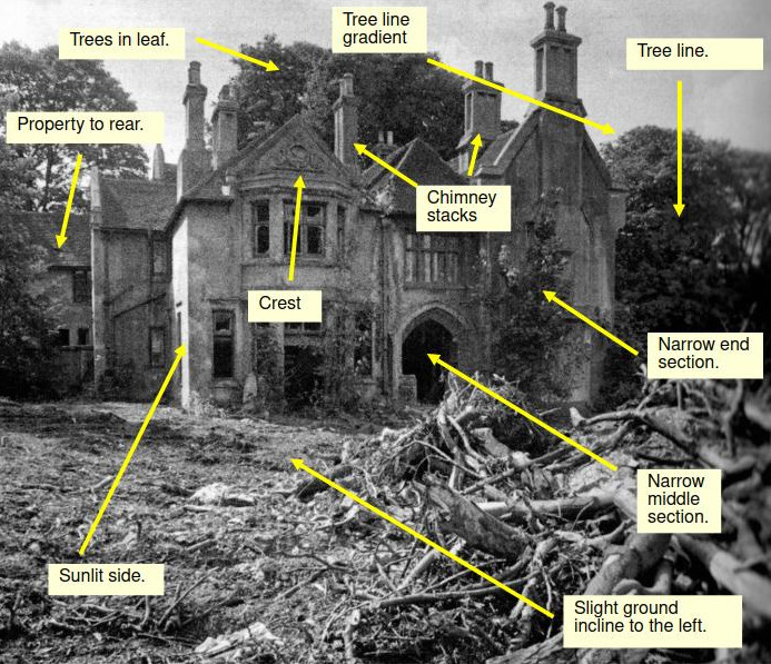
Figure 2: A set of initial clues that might aid in the geolocation of the building. Enlarged version.
- The left-hand side of the house was illuminated by the Sun, suggesting that it faced a Southerly direction. This provided me with an approximate orientation for the building.
- The building appeared to be situated on the side of a hill. There is a slight ground incline rising from the right, and a line of trees moves downwards from left to right.
The Hill Gradient #
Luton sits primarily in the River Lee valley, flanked on the West and East by sections of the Chiltern Hills. Given that the house was illuminated on its left side, and considering the apparent ground gradient falls off towards the right side of the photograph, I hypothesised that the building was likely located on the western hill slope of the town. If the building were on the eastern hill slope, it would be unlikely to be illuminated on its left side.
The Tree Line #
If I could compare the gradient of the tree line (using it as a proxy for the ground) in the historical photograph with the gradient at the location of Highfield House on the 1922 Luton map, I might be able to determine whether they are the same or different. This approach is similar to using the gradient as a “fingerprint” for the location. Clearly, there is lens and perspective distortion in the historical photograph, but in situations like this, one often has to work with incomplete and fuzzy information, making the best use of what is available. None of this falls into the category of designing a standard scientific experiment. I also made the assumption that the trees were approximately the same age and thus had grown at a comparable rate.
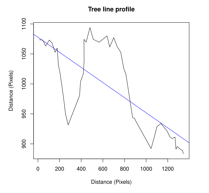
Figure 3: The estimated Bayesian linear regression model of the gradient of the tree line over the width of the historical photograph.
I imported the historical photograph into a CAD package and marked a series of points (the yellow dots) along the tree line.
The x/y coordinates of the points were exported from CAD, giving me a small dataset from which I could compute the linear gradient of the tree line as it descended the apparent hillside (Figure 3).
LiDAR Elevation Gradient #
The next stage involved extracting the LiDAR elevation profile from the area where the tree line was located, which is marked on the historical map. I scanned the historical map, georeferenced it, then downloaded the appropriate 1m resolution LiDAR tile for that area. I created a section line and extracted the elevation data along it. See Figures 4 and 5.
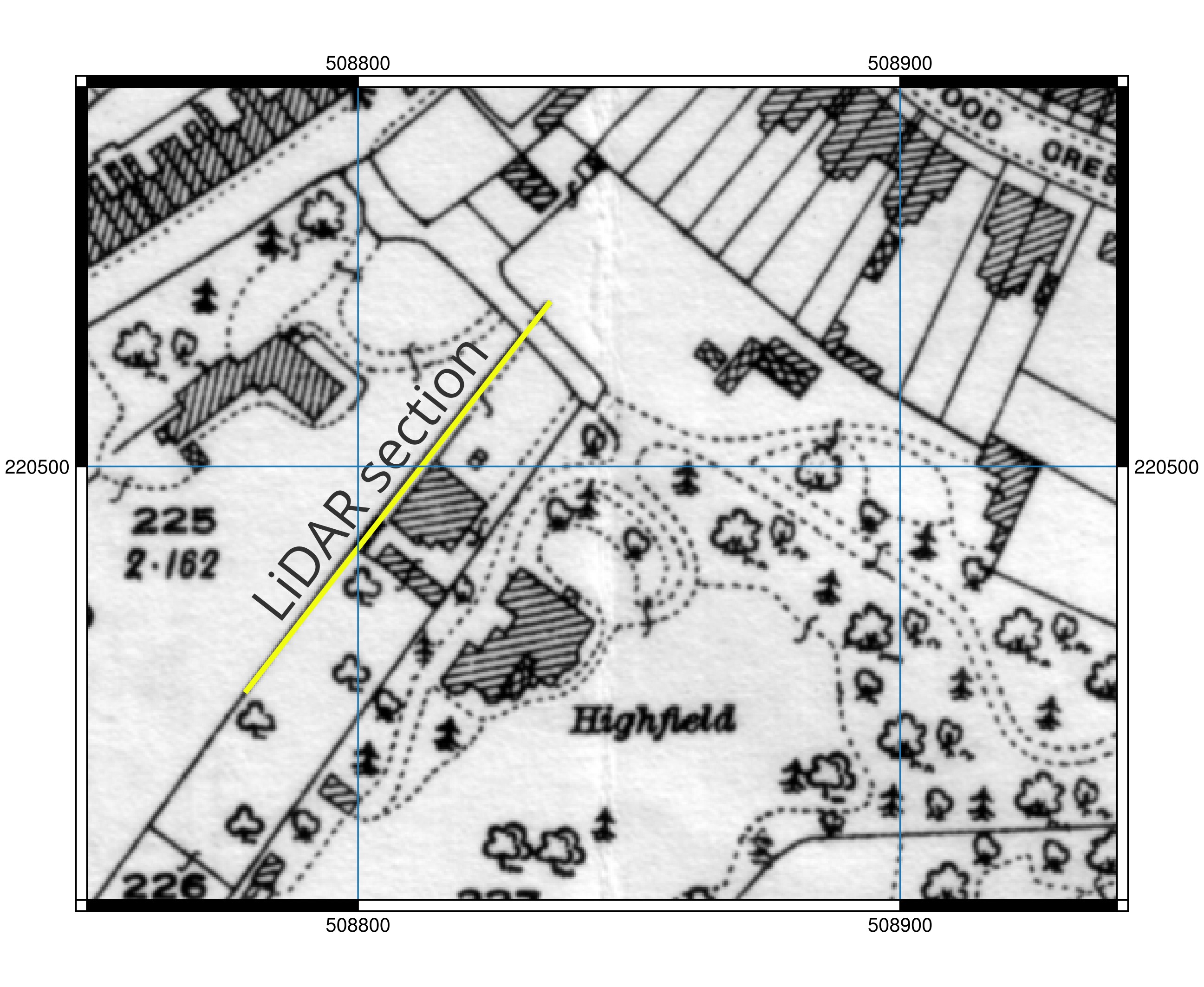
Figure 4: The LiDAR section line with the Godfrey 1922 base map. Enlarged version.
Next, the elevation gradient for the LiDAR dataset was computed (Figure 6). The computed elevation gradient for the tree line was -0.12593805, and the gradient for the LiDAR data was -0.14752863. The difference between these two values is fairly close, measuring 0.02308826.
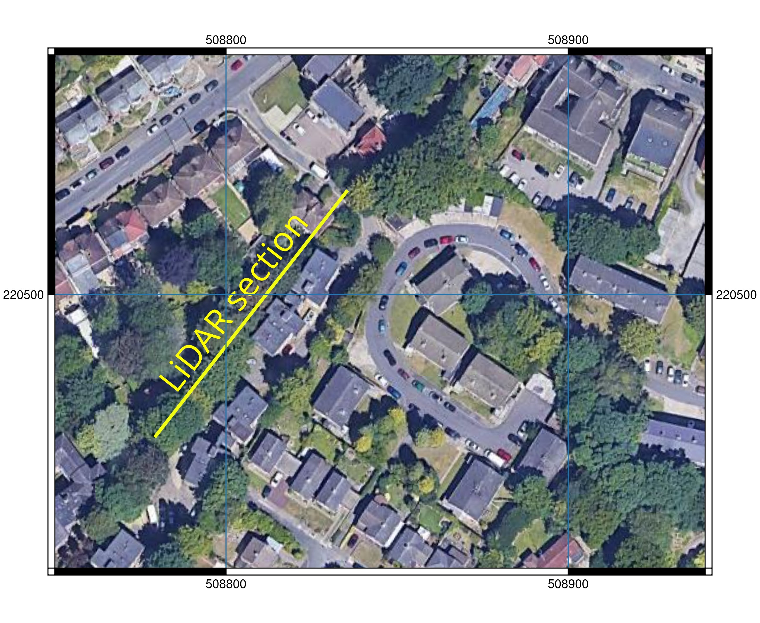
Figure 5: The LiDAR section line with the Google Earth base map. Enlarged version.
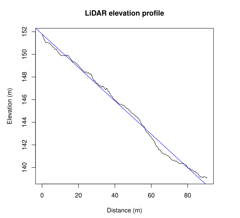
Figure 6: Computed LiDAR elevation dataset profile.
Comparing the Two Gradients #
The following step was to statistically compare the two gradients. Are they significantly different, or are they approximately the same? To answer this question, I developed a Bayesian model and computed it using Markov Chain Monte Carlo simulation in order to find the error distribution of the difference between the two gradients.
The point estimate of the difference of the two gradients was -0.02308826. This value falls nicely within the 95% confidence limits (the yellow region in Figure 7), so from a statistical perspective, it can be concluded that the two gradients are about the same. This result suggests a good chance that the hillside in the historical photo matches the actual ground elevation of that section of the modern map. The two “fingerprints” match!
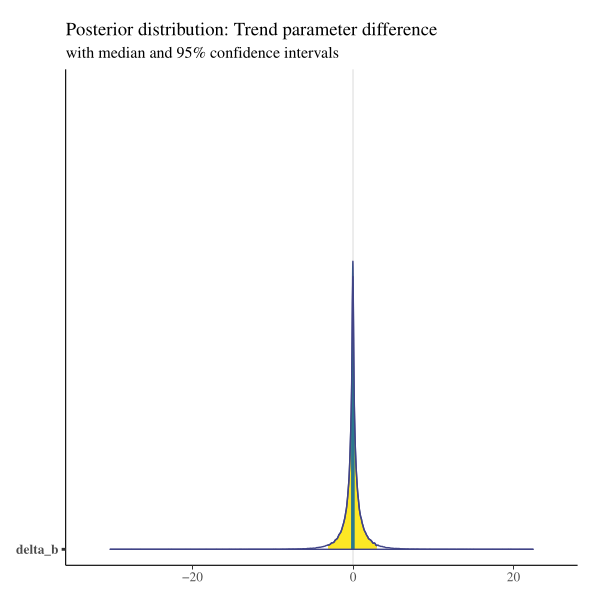
Figure 7: The Bayesian comparison results of the difference between the tree line and LiDAR gradient parameters.
A Conclusion #
To summarise, based on the analysis above, it appears that the “Unknown house” stands a good chance of being Highfield House, which was located on London Road in Luton. The OS grid reference of where Highfield House once stood is TL 08830 20470.
Naturally, there is other evidence that requires further follow-up. I had hoped to obtain some lower altitude historical imagery of the area to check the house structure more closely. There was an RAF image taken of Luton in the 1950s when Highfield was still standing, but unfortunately, it was taken from 25,000ft and was too low resolution to reveal any fine details.
One snippet of evidence that did crop up was that I managed to obtain copies of planning applications concerning Highfield from Luton Council. The most recent application in that list mentioned that 6.356 acres of the Highfield site had been made available for residential development around the time period Stuart Smith mentioned in his book when the original photograph was taken. The houses on the site today look to date from the early 1970s.
Update on 23/08/2025 #
I recently received contact from a gentleman named Brian, who is in Australia, regarding Highfield House. He provided some crucial information about who lived at Highfield. His message read:
“Using your geolocation research, I jumped to the conclusion that your Highfield House was the one that the Henry Brown family and servants was living in at the time of the 1871 census: https://www.wikitree.com/wiki/Brown-198054 Any comments? That’s a great piece of sleuthing you’ve done from one photo!”
According to the 1871 census https://www.wikitree.com/wiki/Cooper-48968 , Elizabeth Brown lived at Highfield. She was the wife of Henry Brown https://www.wikitree.com/wiki/Brown-198053 , the well-known timber merchant in Luton. Stuart Smith’s book does state that the house would have more than likely belonged to a wealthy local business family.
It was really gratifying to receive this feedback, and it has prompted some extra leads to follow up on concerning Highfield.
Brian is currently researching Brown descendants of Daniel Brown, who lived in the rural area in Bedfordshire or Hertfordshire north of Luton. If anyone has any information they would like to share concerning the Browns, please drop me a line, and I will make arrangements to put you in contact with Brian directly.
Page updated: Tuesday, November 17, 2026.