The Maulden Bridleway Incident
Background Context #
The British Horse Society (BHS) pursued the designation of a bridleway through the graveyard of St Mary the Virgin Church in Maulden, Bedfordshire. Although Central Bedfordshire Council (CBC) rejected the BHS’s 2022 application, the Planning Inspector subsequently permitted an appeal. This appeal was granted based on historical documentation suggesting the route had previously served as a bridleway.
The BHS’s claim was based on pre-Ordnance Survey maps dating back to the 1700s. However, CBC’s definitive map showed no evidence of such a pathway crossing the churchyard area, a lapse which later proved to be an oversight by the Council.
The churchyard extension itself was allocated during the late 1800s or early 1900s. At that time, the area was open fields. Consequently, the Council presumably granted planning permission decades ago, as there was no visible indication of a public right of way crossing the land. As the 1900s progressed, this newly developed section of the churchyard was gradually populated with burials, a practice that continues to this day.
Maulden Parish Council (MPC) #
The affair quickly gained national media coverage. See the The BBC article . The outrage among the villagers of Maulden was profound. MPC held an extraordinary public meeting in April 2026 to present the evidence to local residents, at which point the situation began to escalate rapidly.
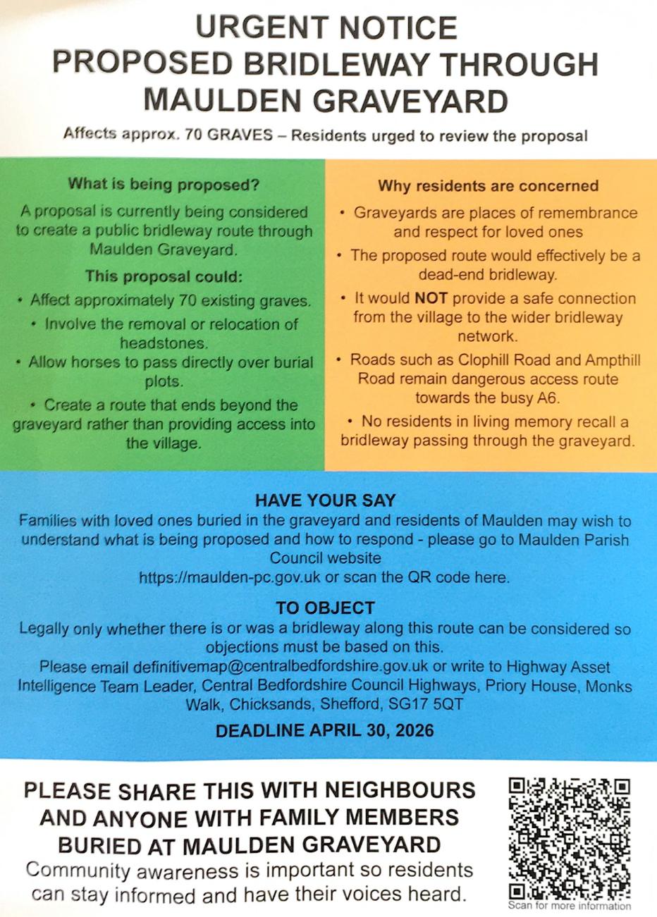
The flyer leaflet posted to residents by Maulden Parish Council in April 2026. Enlarged version.
The core conflict was stark: a failure in CBC’s definitive mapping had been exposed, suggesting that the permission granted for the churchyard extension decades ago should never have been given. If the Law were enforced to its maximum extent, it would necessitate reopening the bridleway, leading to the destruction of numerous graves that had been in place for decades, including very recent burials.
The Parish Council received numerous submissions from residents, many containing historical maps purporting to show the bridleway’s route. There was significant disparity in this mapping:
- Some documents marked the track as a footpath, while others designated it as a bridleway. Even late 1800s/1900s Ordnance Survey maps were uncertain about the precise designation.
- Crucially, these historical maps were not geo-referenced. The oldest versions lacked any grid system, while the 1800–1900 OS maps used latitude and longitude. All the historical mapping predated the churchyard extension, and although the track way was marked, its precise location relative to the future churchyard remained highly conjectural.
My Involvement #
I became involved in this matter for three primary reasons:
- I strongly objected to what could only be described as the desecration of a quiet country churchyard, acutely aware of the immense distress this would cause to villagers with relatives buried there.
- The incident presented a serious threat to a historical site.
- I had previous technical involvement with the site. Between 2009 and 2014, I had mapped the location of every grave for Maulden History Society , producing detailed maps as part of their churchyard survey.
The Plan of Action #
The immediate objective of my investigation was to determine conclusively whether the track way depicted on the historical maps actually crossed the churchyard extension. Given the multitude of conflicting historical documents presented, a definitive spatial answer was urgently needed. My second concern was identifying precisely which graves would be impacted should the route be reopened.
To achieve this, I created a composite map for Maulden Parish Council. This map integrated three key layers: the modern base mapping, the track way course sourced from a historical 1902 Ordnance Survey map, and the grave locations derived from my original survey CAD drawings. All of this data was meticulously geo-referenced into the OSGB36 coordinate system, providing a clear, spatial record of everything concerned.
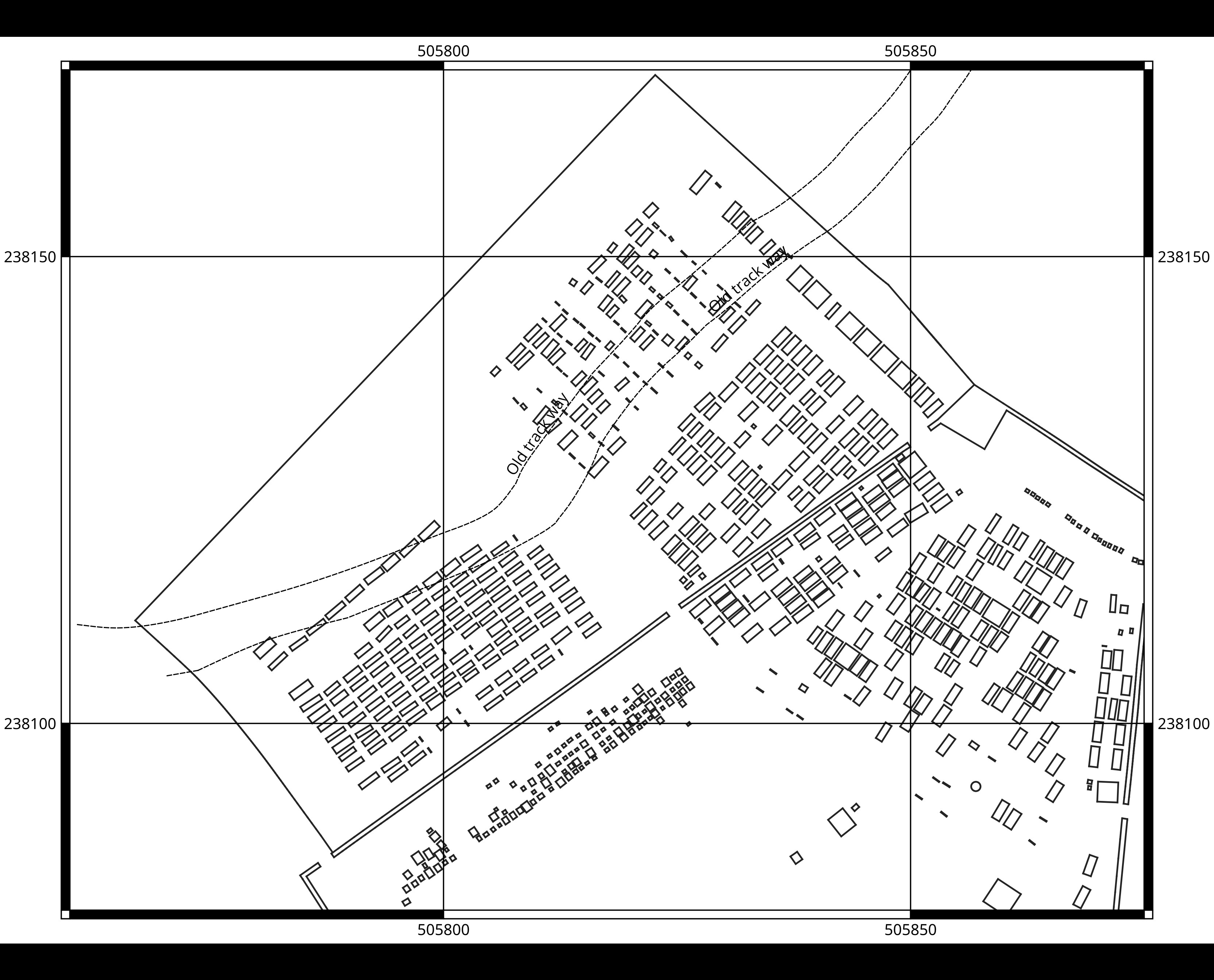
Figure 1: The composite map showing a section of the churchyard with the course of the marked OS 1902 bridleway re-projected into OS grid coordinates (the dotted lines), and finally my grave location survey of 2014. Enlarged version.
My findings were not favourable to the residents. The evidence clearly showed that the track way did cross the churchyard (see Figure 1). I subsequently submitted these results to the Parish Council and awaited their decision.
The Next Phase #
MPC submitted various evidence to the council regarding the whole affair, including the submissions from local residents and, naturally, my own mapping data. The net result was that a temporary closure order for the historical bridleway was issued. It is important to note that there is no ground evidence of a bridleway passing through the churchyard. Furthermore, the churchyard is bounded on the northern perimeter by a high thick Holly bush hedge, a feature that has been in place for many years.
The Next Problem #
The historical course of the bridleway exits the churchyard on the western edge and joins Woodcocks Path. This path travels down into the village, entering George Street. As the path enters George Street, it is flanked by two private properties. The width of the path at this point is much less than the designated bridleway width of 4 metres. Should the Law be enacted to its maximum extent, at least one of the properties would need to have a side demolished.
Accurate measurements of the entrance were required at this point to quantify the necessary clearances. While a simple visual inspection clearly shows that the path is insufficiently wide, precise measurements were necessary.
Figure 2 shows the exit point of the path as it enters George Street. I needed to measure the distance between the far corner of the wall on the house to the left and the right-hand side wall bordering the path. A similar measurement was also required for the front corner of the left-hand side house to a comparable point on the wall on the right.
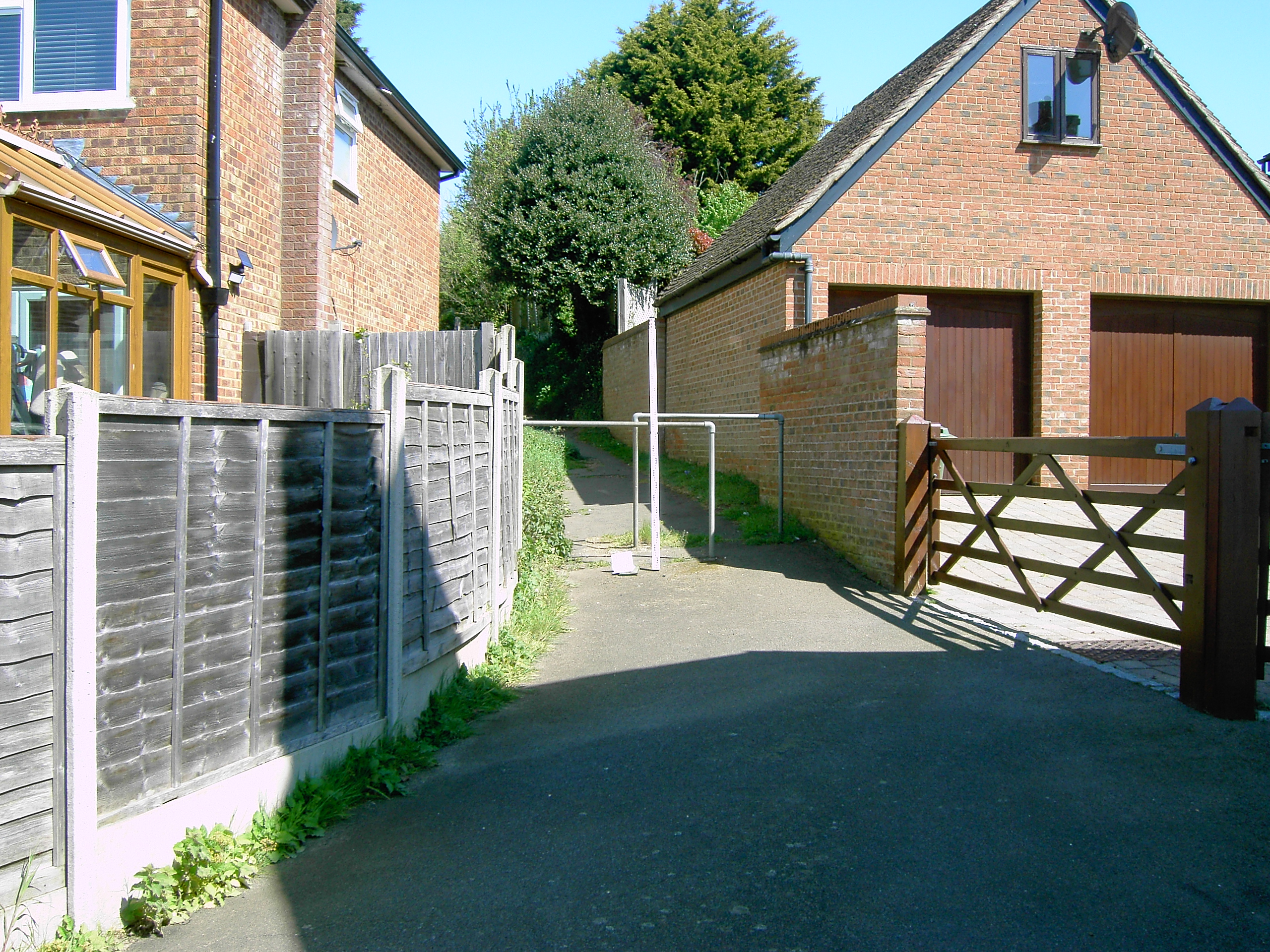
Figure 2: One of my Photogrammetry survey images of the endpoint of Woodcocks Path. Enlarged version.
The resulting measurements, as shown in Figure 3, indicate that the clearance of 2.6 metres is far too narrow at the building rear section to accommodate any necessary extension to the path width. Where the path does widen out to 4.7 metres at the front of the building. I submitted these results to the Parish Council so they could incorporate them into their already growing evidence against reopening the bridleway.
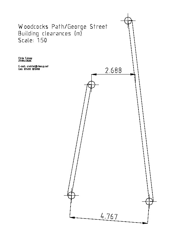
Figure 3: Photogrammetry measurements of the wall clearances at the endpoint of Woodcocks Path. Enlarged version.
Central Bedfordshire Council Response #
After being inundated by the local community response to the entire affair, CBC responded by suggesting that they intended to reroute the bridleway away from the churchyard and Woodcocks Path, directing it around the perimeter of the second churchyard extension. This second churchyard extension is an area of land immediately to the west of that shown in Figure 1.
My Parish Council liaison, Councillor Smith, contacted me because she wanted to stop the CBC re-routing proposal. She had heard of my work involving hydrological mapping in the village and hoped that I could counter CBC’s proposal by highlighting potential ground flooding issues that might pose health and safety concerns to anyone using the bridleway.
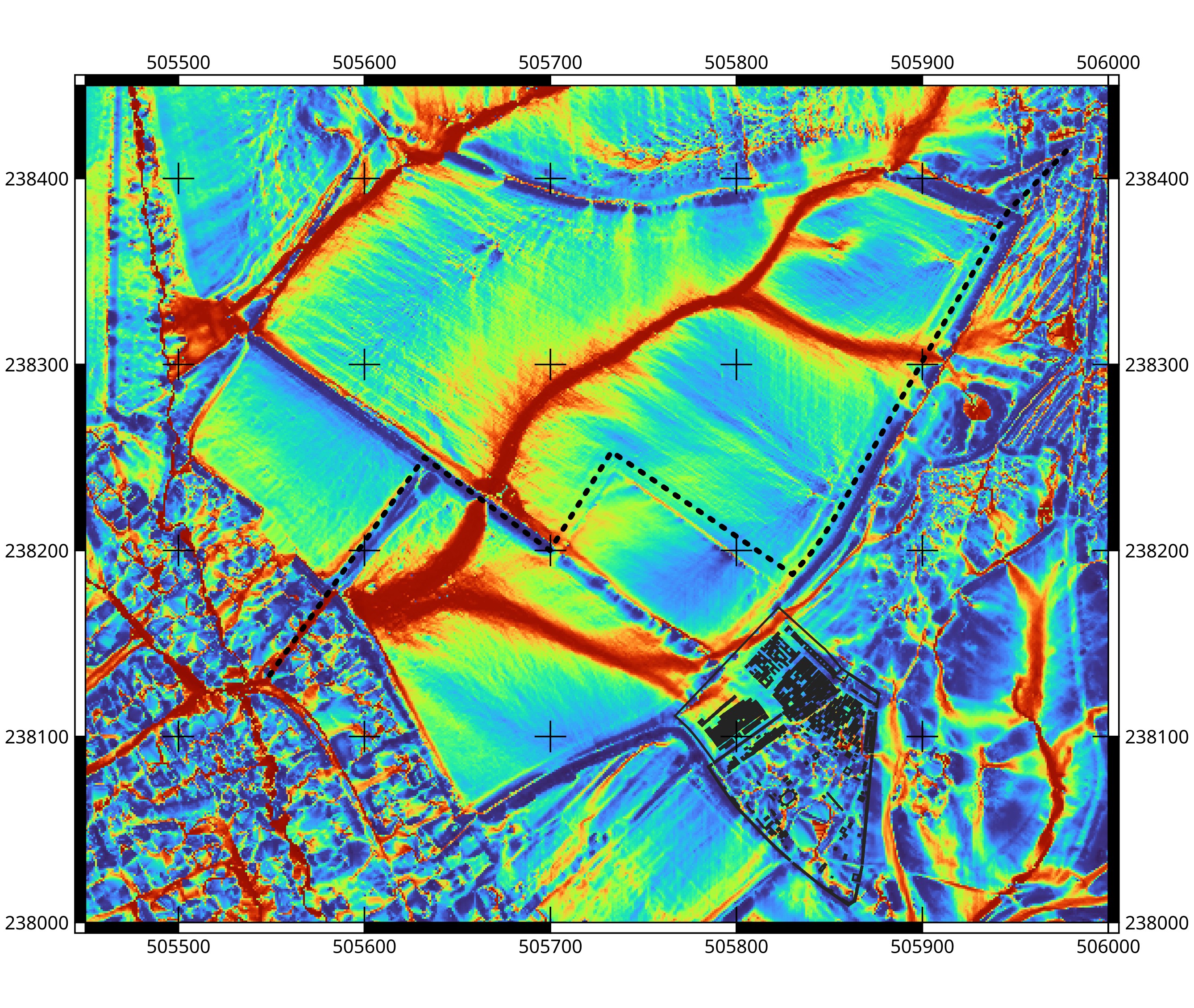
Figure 4: The Topographic Wetness Index (TWI) around the proposed diversion route. The thick dotted line indicates CBC's proposed redirection path. Enlarged version.
I prepared Councillor Smith a Topographic Wetness Index (TWI) map of the area surrounding the proposed redirection route (Figure 4). TWI indicates the propensity of the land surface to accumulate water. For details regarding the implications of this see my TWI notes .
The red areas on the map highlight high TWI locations. In these zones, the water table is elevated, resulting in the ground having a higher soil moisture content than its surroundings. If the area experiences sudden and heavy precipitation events, these zones will rapidly become waterlogged. There are four points where the proposed redirection route crosses high TWI areas.
Devils Advocate Analysis #
In September, I undertook a Devil’s Advocate Analysis of the original application submission , conducted alongside a legal colleague. While I have not previously released the results of this analysis, I have decided to do so now as I believe it may be useful to anyone who is challenging this issue. The analysis results are linked here .
Conclusions #
Maulden Parish Council published an update regarding the matter on their website on the 19th of November 2026. Their news update article states that the temporary closure of the claimed bridleway has now been extended until the 25th of November 2028 or until the bridleway is diverted, which is at least some small amount of good news for the village and churchyard.
I did meet with Councillor Smith in August, and she informed me that my mapping had indeed impacted CBC’s response regarding the whole bridleway incident. In particular, she stated that my TWI mapping alone had successfully thwarted CBC’s attempt to re-route the bridleway around the second churchyard extension.
Page updated: Friday, November 20, 2026.